Gower
It's amazing what you can find on the internet when you are bored and have some free time. Patty's family has been digging into their back ground and it got me thinking so I started playing around on the internet.

When the ancestors of the Gower family emigrated to England following the norman Conquest in 1066 they brought their family name with them. They lived in the district north of Paris which is known in Old French as Gohiers. There are also places in Normandy called Gouy to which the Anglo - Norman French suffix er was added to make Gower
Gower Street is a street in Los Angeles, California that has played an important role in the ongoing evolution of Hollywood, particularly as the home to several prominent Poverty Row studios during the area's Golden Age. It marks the eastern terminus of the Hollywood Walk of Fame.
Gower Street begins at the corner of First Street in the Hancock Park district as a residential street, becomes primarily industrial, and then commercial as it bisects the Hollywood district, becomes residential again north of Franklin Avenue, and terminates in Beachwood Canyon at Beachwood Drive near the Hollywood Sign. Gower Street marks the western boundary of the Hollywood Forever Cemetery just south of Santa Monica Boulevard.
Many of the original Hollywood movie studios were located on or near Gower Street. The Paramount Pictures lot sits on the corner of Gower Street and Melrose Avenue; further north, the Sunset Gower Studios (formerly the Columbia Pictures lot) sit on the corner of Sunset Boulevard and Gower.
The Hollywood Walk of Fame (which runs east to west on Hollywood Boulevard) begins at the corner of Hollywood Blvd. and Gower Street.
Beginning in the 1930s, Gower Street earned the nickname "Gower Gulch" because of the many extras in Westerns who would dress in their cowboy costumes at home, then walk south to Paramount, Republic, and RKO studios, which were all located just off Gower Street south of Sunset Boulevard. Today, a strip-mall named "Gower Gulch," built to resemble a Western set, sits on the southwest corner of Sunset and Gower as a reminder of that era. The phrase "Gower Gulch" is painted on an actual chuck wagon that sits on the site of the old "Copper Skillet" coffee shop, where the cowboys used to have their breakfast.


Gower Street is a street in Bloomsbury, Central London, England, running from Montague Place in the south to Euston Road at the north. The street continues as North Gower Street north of the Euston Road. To the south it becomes Bloomsbury Street.

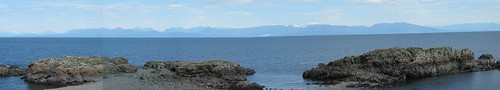
Gower or the Gower Peninsula (Welsh: Gwyr or Penrhyn Gŵyr) is a peninsula in south Wales, jutting from the coast into the Bristol Channel, and administratively part of the City and County of Swansea. Locally it is known as "Gower" (not "the Gower"). In 1956 Gower became the first area in Britain to be designated an Area of Outstanding Natural Beauty.
About 70 square miles (180 km2) in area, Gower is known for its coastline, popular with walkers and outdoor enthusiasts, especially surfers. Gower has many caves, including Paviland Cave and Minchin Hole Cave. The peninsula is bounded by the Loughor Estuary to the north and Swansea Bay to the east. Gower Area of Outstanding Natural Beauty covers 188 km², including most of the peninsula west of Crofty, Three Crosses, Upper Killay, Blackpill and Bishopston.[1] The highest point of Gower is The Beacon at Rhossili Down at 193m/633 ft overlooking Rhossili Bay.[2] Pwll Du and the Bishopton Valley form a statutory Local Nature Reserve.[3]
The interior of Gower consists mainly of farmland and common land. The population resides mainly in villages and small communities, though suburban development has made a number of communities in eastern Gower part of the Swansea Urban Area.[4]
The southern coast consists of a series of small, rocky or sandy bays, such as Langland and Three Cliffs, and larger beaches such as Port Eynon, Rhossili and Oxwich Bay. The north of the peninsula has fewer beaches, and is home to the cockle-beds of Penclawdd.


North Gower is an official Village within the amalgamated City of Ottawa.
North Gower is a village located approximately 20 minutes south east of the City of Ottawa, an was included in the 2001 amalgamation. Easily accessible from Highway 416, North Gower shares most of its amenities with the surrounding villages of Richmond, Kemptville, Kars, and Manotick. First settled in 1846 by David Barrows, Silas Andrews, William Craig and Russell Andrews, it is in the centre of what is now the Rideau Township. Its sits along Steven’s Creek, in a rich and well cultivated agricultural area.

These are just a few of the things I have found on the internet. There are Schools that are named Gower including a Gower School District in Chicago. Its hard to know where to begin or where to end so I'll end it here for now.


